Plymouth Marine Laboratory (PML) provides the oil spill detection service to ten West African countries as part of the European Space Agency’s Earth Observation for Sustainable Development (EO4SD) – Marine & Coastal Resource Management.
The team, in partnership with the Centre de Suivi Écologique (CSE) in Dakar, uses imagery from the Synthetic Aperture Radar (SAR) sensors onboard the Copernicus Sentinel-1 satellites to detect areas of wave dampening compared to surrounding water. These patches of darker smooth surfaces indicate the presence of oil slicks.
All detected spills are reported back to relevant stakeholders across the region, with particular attention given to detections that are either significant (covering several square kilometres) or frequent. This can allow quick responses in the form of remediation and clean up in order to reduce the environmental impact and prevent oil reaching sensitive habitats and coastal communities.
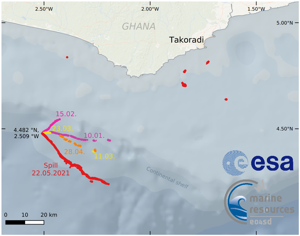
Through analysis of detected slick locations since the start of 2021, the service has identified large-area spills or oil discharges coming at least once a month from around the same location in Ghana, a country which has been building up its crude oil production over the last decade. Analysis of vessel traffic data by the University of Ghana’s Department of Marine & Fisheries Science supports the idea that these spills are likely coming from oil exploration activities. Findings are being communicated to both the Ghanaian Navy and Environmental Protection Agency, who are following up to determine the best course of action from within the country.
Using Earth Observation to monitor oil spills in this way is much more cost-effective than attempts to monitor large areas using boat or aerial surveys. Additionally, the data can be combined with computer models of ocean surface currents to indicate where spills might reach vulnerable coastal habitats and highly populated areas.
Finding patterns of spills around shipping lanes and oil fields over the years helps to understand the risks of oil spills and inform coastal management. Future work could also incorporate national ship identification data to identify more precisely which ships or platforms are polluting the water.
The service utilizes Sentinel-1 Synthetic-Aperture Radar (SAR) imagery and is provided in partnership with the Centre de Suivi Écologique (CSE) in Dakar. The service reports detected spills and provide coordinates to relevant regional stakeholders, as well as weekly summaries of all detections. Detections indicate significant spills (covering multiple sq. km) or oily discharges that occur frequently (weekly).
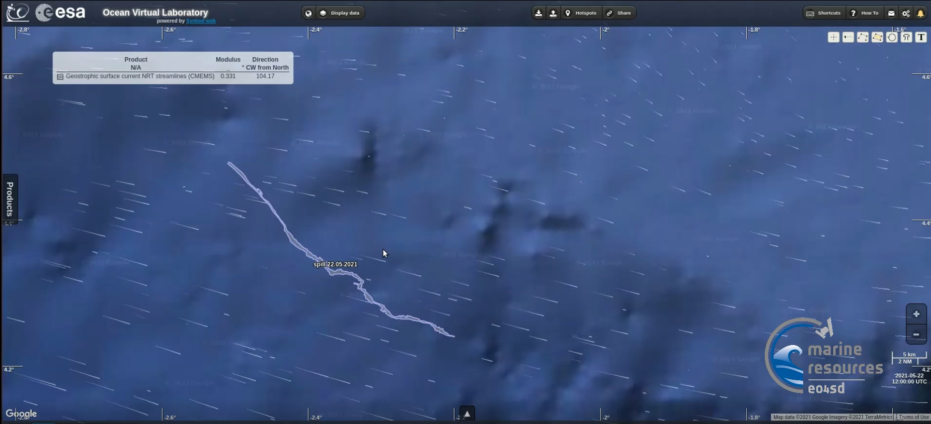
In Ghana, the service has identified large-area spills or discharges occurring at least every month originating from approximately the same location. Each spill affects over 10 sq. km of the sea surface, an area larger than 1,400 football pitches. Oil development along the West African coastal shelf is increasing; in particular, Ghana’s energy sector has been expanding its crude oil production with the recently opened Twenboa-Enyenra-Ntomme (TEN) and Offshore Cape Three Points (OCTP) fields following the International Tribunal for the Law of the Sea (ITLOS) ruling in the last half of 2017. Oil slicks can cause significant damage to the marine environment as well as negatively affect the health and livelihoods of local people. Quick remediation and cleanup responses aim to reduce impact and prevent spills from reaching sensitive coastal habitats and exposing coastal communities.
Monitoring for oil spills by boat or aerial surveys over large areas, such as the national 370 km wide Exclusive Economic Zone (EEZ), would be prohibitively expensive, where operational monitoring services use Earth Observation (EO) data provide a more cost-effective solution for initial detection. Overlaying the most recent detected oil spill (measuring 18 sq. km) onto ocean surface current models indicate that these spills could be reaching heavily populated areas such as Accra and important coastal habitats such as the Keta Lagoon Ramsar.
Dr Elizabeth C. Atwood, PML Earth Observation Data Analyst, said: "In-depth analysis of spatial patterns in slick occurrence over time in relation to shipping lanes, oil fields and EEZ boundaries would substantiate hypothesised sources of risk for oil spills within a nation’s coastal waters. Such an analysis, including assessment of risk to sensitive coastal habitats, would be of central interest for coastal planning agencies aiming for sustainable development."
Dr Moussa Sall, Director of CSE, Coordinator of the regional unit of the West African Coastal Observation Mission, added: “The detection of oil spills on the West African coast is of great importance in the fight against marine pollution, especially in a context where the exploitation of oil will develop with new discoveries of deposits in certain countries and with the densification of maritime traffic.
The technical support provided by Plymouth Marine Laboratory (PML), under EO4SD-Marine & Coastal Resource Management, in the use of satellite images for this purpose, is capitalized through capacity building sessions for the network of experts in the sub-region. The forthcoming establishment of the regional observatory and national observatories will, in the medium and long term, make it possible to tackle the issue in a sustainable manner at the local level. Provision of marine pollution indicators can thus be retained in the monitoring program of the regional observatory.
The information produced will be made available at the level of the regional observatory platform and will also be capitalized upon in the regional alert network. All this will contribute to improving knowledge on coastal risks and help in decision-making in the management of the West African marine and coastal area.”
Dr Kwame A. Agyekum, Dept. Marine & Fisheries Sciences, University of Ghana, said: “This collaborative activity has the potential of increasing the number of local expertise within the sub-region in the utilization of radar imageries and other forecasting tools to understand the behaviour of oil spill within the seas of West Africa. It is imperative that institutions in the region take advantage of this technical-know PML is bringing onboard and adopt innovative technology in safeguarding the maritime space.”
Watch the Video on the Oil Spill, Ghana (click image below)